
Testing Underway on AI Platform to Aid Great Lakes Navigation
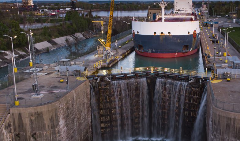
Since opening in 1959, the Great Lakes St. Lawrence Seaway System has remained a vital mode of maritime transportation for the movement of goods between North America and international markets, moving more than 2.5 billion metric tons of cargo, with an estimated value of $375 billion. Hundreds of commercial vessels from more than 50 countries make 3,000 to 4,000 transits each year on the system.
How It Developed
Over the last 66 navigation seasons, the system has seen significant transformations in infrastructure and technological advancements, all aimed at creating a more efficient and streamlined supply chain corridor. The St. Lawrence Seaway became the first waterway in North America to introduce Automatic Identification System (AIS) technology for vessel traffic management and shore-to-shore communication. Within the last decade, modernization of the locks and bridges led to remote operations, hands-free mooring and redesigned traffic control centers. “Artificial intelligence wasn’t a topic when we started these modernization projects, but in 2021, as technology evolved, we began looking into what more we could do, and AI became a topic of conversation,” said Jack Meloche, general manager of marine information systems for SLSMC.
In 2022 a team was put together to research the capabilities of AI, along with the formation of budgets and funding for the bi-national project. In early 2023, the joint venture between the Canadian and U.S. agencies operating on the Great Lakes St. Lawrence Seaway System started the process of creating a data sharing program that will include the carriers, shippers, pilotage authorities, ports, terminals, ship agents or agencies and the Canadian and U.S. Coast Guards. Meloche said this program will go through multiple versions over the next several years. He hopes that by 2027 most stakeholders doing business on the system will have provided data exchange processes and be utilizing the new system as a support for their operations.
What Is VIS?
Meloche said the VIS is an algorithm and connectivity platform that can connect all stakeholders, both external and internal, on the Great Lakes St. Lawrence Seaway System.
The VIS has two functions—to serve as an all-encompassing platform for external stakeholders, from ports to carriers, where they will be able to access information on locks, bridges and canals within the Seaway System. At the same time, staff in the traffic control centers can use the platform internally to improve maritime traffic management efficiency on the seaway.
Meloche said the system is being built mostly through data sharing and application programming interface (API). An API is a set of protocols that enables software applications to exchange data and communicate with each other. Travel booking sites, rideshare apps, Google Maps and PayPal all use APIs for actions like payments, reservations and locations. Meloche said not all stakeholders currently have APIs. “We don’t want to be a burden or create extra costs to users and stakeholders,” he said. “Through our conversations we can see what information ports, terminals or carriers have and how that data can be utilized within the VIS.”
There are currently five stakeholders testing the VIS, two ocean front companies and three inland companies. Meloche hopes their input and data sharing will be able to improve the system from version 1.0 to 1.1 by early this summer. By then, the goal is to have other stakeholders involved who want to participate and possibly have version 1.2 up and running for the 2025 navigation season.
Some of the third parties helping to build the AI platform are companies already involved in AI and in the marine industry. The Volpe Center, a division of the U.S. Department of Transportation, provides multimodal transportation expertise. The Volpe Center created the connectivity program the U.S. airline industry uses and has provided transportation support for more than 50 years. Halifax-based Global Spatial Technology Solutions (GSTS), which has helped build ETA schedules for The CSL Group and the Port of Montreal, creates AI platforms for the maritime industry. Spiria, a firm specializing in website design and user experience, is also working on the VIS. Meloche said the advanced graphics will eventually allow vessels to add certain layers like weather radar over the top of the system graphics, allowing them to see what the weather will be as they travel the seaway. Both the U.S and Canadian Coast Guards are working on e-navigation, new standards on water levels, surface currents, and electronic buoys, so these types of maps may also be available to users in the future.

What It Can Become
Over the last few months, Meloche and his team have been meeting with a variety of stakeholders, including ports, terminals, representatives from the Soo Locks, and the U.S. Army Corps of Engineers to show them how they can utilize VIS for traffic management. “We are going to look to see if we can expand some of our data points,” Meloche said. “We want to build something that everyone sees value in. Down the line, we might be able to create a transit for a ship leaving the Port of Thunder Bay, for example, and provide an expected arrival time at a lock, such as the Soo Locks.”
Once the system is available, and a stakeholder has access to the VIS, the information they can see depends on their role in the industry. For example, carriers will only be able to see specific route details related to their vessels, not a competitor. “If you are a carrier, you can see details for your ships, as well as lock schedules, vessel speeds and ETAs at seaway structures,” Meloche said. “But, if you click on a competitor’s ship you will see the basic information that the AIS transponder is giving out, nothing more.”
How It Benefits the Seaway
Meloche believes all stakeholders can benefit from the VIS. Ports will be able to keep track of ships coming in and out and the type of cargo being unloaded or loaded. Carriers and ship captains will see how many vessels are waiting in line at a lock and possibly decide to slow down to save fuel. “This is our way to validate what AI can do for traffic planning on the seaway,” he said. “Our plan is to build in more information over time. AI is a planning tool. We will be able to see in real time where the congestion is on the seaway.”
Meloche said the creation of the system continues to evolve. “AI wasn’t part of the discussion when we started modernizing the seaway seven or eight years ago,” he said. “And we have no idea what type of technology will exist three years from now.”
Meloche pointed out that the maritime world is conservative, so just building the connectivity platform is a big step toward embracing what technology can do for the industry. “We have many stakeholders that see the need to move forward,” he said. “We need to be at the forefront, not the backend, of this new technology.”


Transportation Secretary Tours Ports of Indiana-Burns Harbor Expansion Projects
U.S. Transportation Secretary Sean P. Duffy visited Ports of Indiana-Burns Harbor on Lake Michigan on June 19 to tour expansion projects and discuss the role of Great Lakes and inland... Read More
The Enduring Value of the Great Lakes-St. Lawrence Seaway
The Great Lakes–St. Lawrence Seaway remains one of North America’s most strategically important trade corridors, quietly underpinning economic activity across the industrial Midwest while connecting the heartland of the United States to global... Read More